


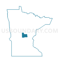
Royalton Voting District, Morrison County, Minnesota
About
Outline
Summary
| Unique Area Identifier | 603180 |
| Name | Royalton Voting District |
| County | Morrison County |
| State | Minnesota |
| Area (square miles) | 1.68 |
| Land Area (square miles) | 1.68 |
| Water Area (square miles) | 0.00 |
| % of Land Area | 100.00 |
| % of Water Area | 0.00 |
| Latitude of the Internal Point | 45.83222280 |
| Longtitude of the Internal Point | -94.29186030 |
Maps


Graphs
Select a template below for downloading or customizing gragh for Royalton Voting District, Morrison County, Minnesota


Neighbors
Neighoring Voting District (by Name) Neighboring Voting District on the Map
- Bellevue Township Voting District, Morrison County, MN
- Langola Twp. Voting District, Benton County, MN
- Royalton Voting District, Benton County, MN
Top 10 Neighboring County Subdivision (by Population) Neighboring County Subdivision on the Map
- Royalton city, Morrison County, MN (1,239)
- Bellevue township, Morrison County, MN (1,093)
- Langola township, Benton County, MN (906)
- Royalton city, Benton County, MN (3)